

When the economy outgrows the map
An economy can move into its cities long before the political system that it operates under, follows it. Nineteenth-century Britain offered one of the first examples of this taking place in a ‘democratic’ system as industrial centres expanded rapidly2 while their parliamentary representation remained attached to an older geography of power. ‘Rotten boroughs’, once-important settlements whose populations had dwindled, kept their seats such that by the time of the 1832 Reform Act, one such borough, Old Sarum, still returned two MPs despite having just a handful of electors. On the other hand, Birmingham, the rapidly expanding industrial city that would become known as Britain’s second city, had no borough MPs of its own; its eligible voters were represented through Warwickshire’s county seats.1 Manchester, the rising textile hub, was in the same position as Birmingham.
The Reform Act finally gave both cities their own MPs, and the political map began to recognise the economy that industrialisation was creating. The reform created 41 new English parliamentary boroughs returning 63 MPs. These constituencies often became important bases for manufacturing and commerce, including support for free trade and industrialisation. Representation gave organised political expression to an economic transformation that was already under way. Universal franchise makes India’s circumstances quite different, but the institutional problem is recognisable; people and production can change location faster than political power.3
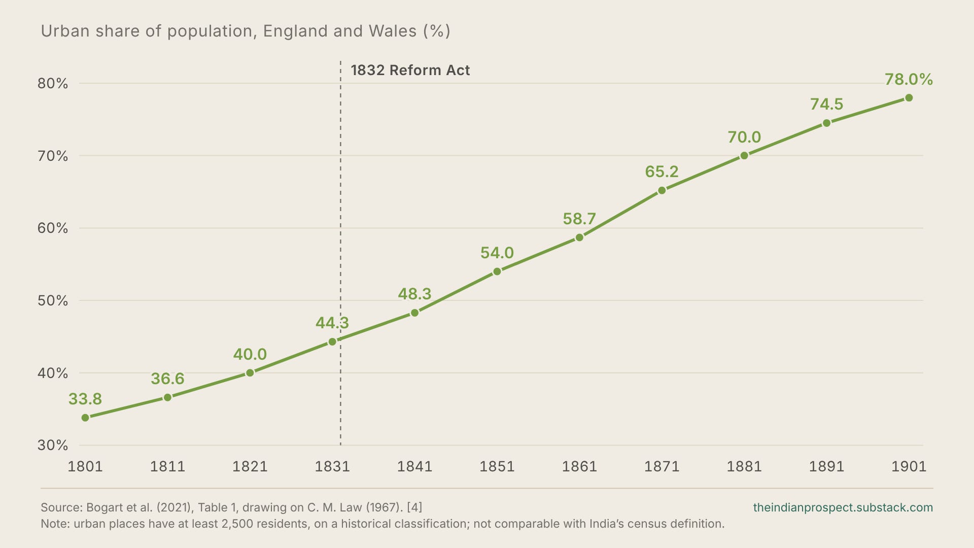
Throughout history, industrialisation and urbanisation have usually advanced together. Firms and specialised workers concentrate where they can find one another, with a view to reach larger markets and become more productive. Sustaining that concentration requires housing, infrastructure and a responsive government capable of dealing with the challenges of such a change. As the economy changes, political power must adapt to the places driving its growth; otherwise the institutions inherited from an agrarian society obstruct its transformation.5
Urbanisation therefore creates a set of political demands of its own. For example, a professional who moves to Bengaluru for a job needs a home within reasonable reach of work, reliable transportation and functioning public services. As more households organise their lives around these needs, governments have more seats to lose when cities fail to meet these demands. At least that’s how it’s supposed to work in theory.
Instead, India has inhibited that adjustment. Its growing metropolitan regions carry increasingly large electorates, while their local governments still remain subordinate to institutions operating at a scale that’s outdated by decades. Two reforms have to follow. Cities need their proportionate weight in the state and national legislatures that decide how much is invested in them, and more authority over their own governments. Getting the requisite representation is the more basic of the two, because only legislators can grant cities that authority, and delimitation is where the quest for this representation begins.
One MP, twice the voters
Let us start with Bengaluru, a city that has seen some of the greatest transformations in recent decades. The Bangalore North parliamentary constituency includes areas like Hebbal, Byatarayanapura and K.R. Pura,7 and as of the 2024 general election it contained 32.15 lakh registered voters. Meanwhile, the largely agrarian Haveri constituency contained 17.94 lakh.6 Despite this drastic imbalance, each constituency elected one MP with Bangalore North carrying almost 80% more voters behind the same single parliamentary seat.
This imbalance in representation survives across a broader statewide comparison. Karnataka averaged 19.56 lakh voters across its 28 parliamentary constituencies; the Bangalore North constituency was 64% above that average. This is a disparity within one state, independent of the far more charged dispute over how many seats southern or northern states should receive, which is why an urban case for delimitation cannot be reduced to that interstate debate.6
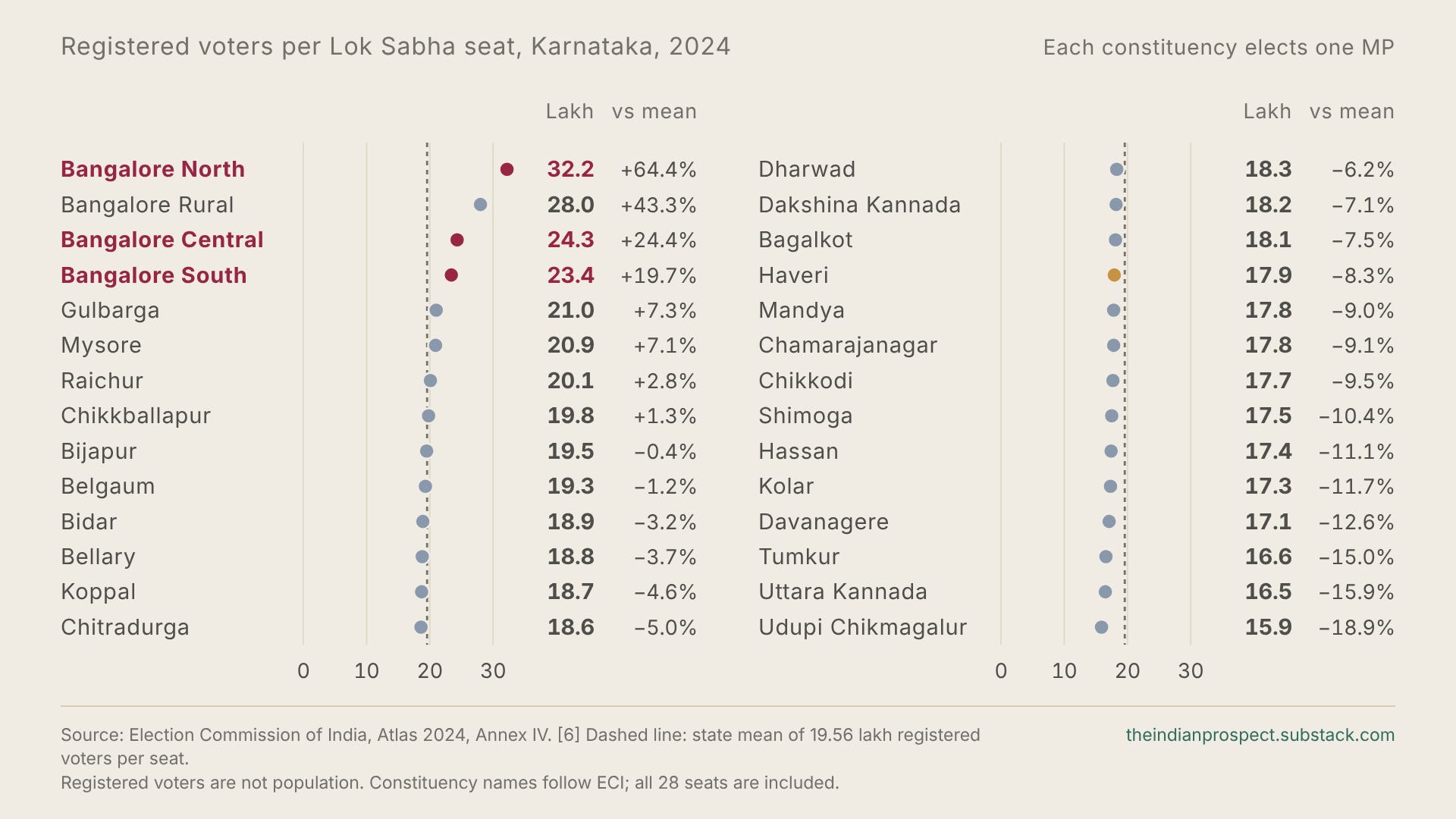
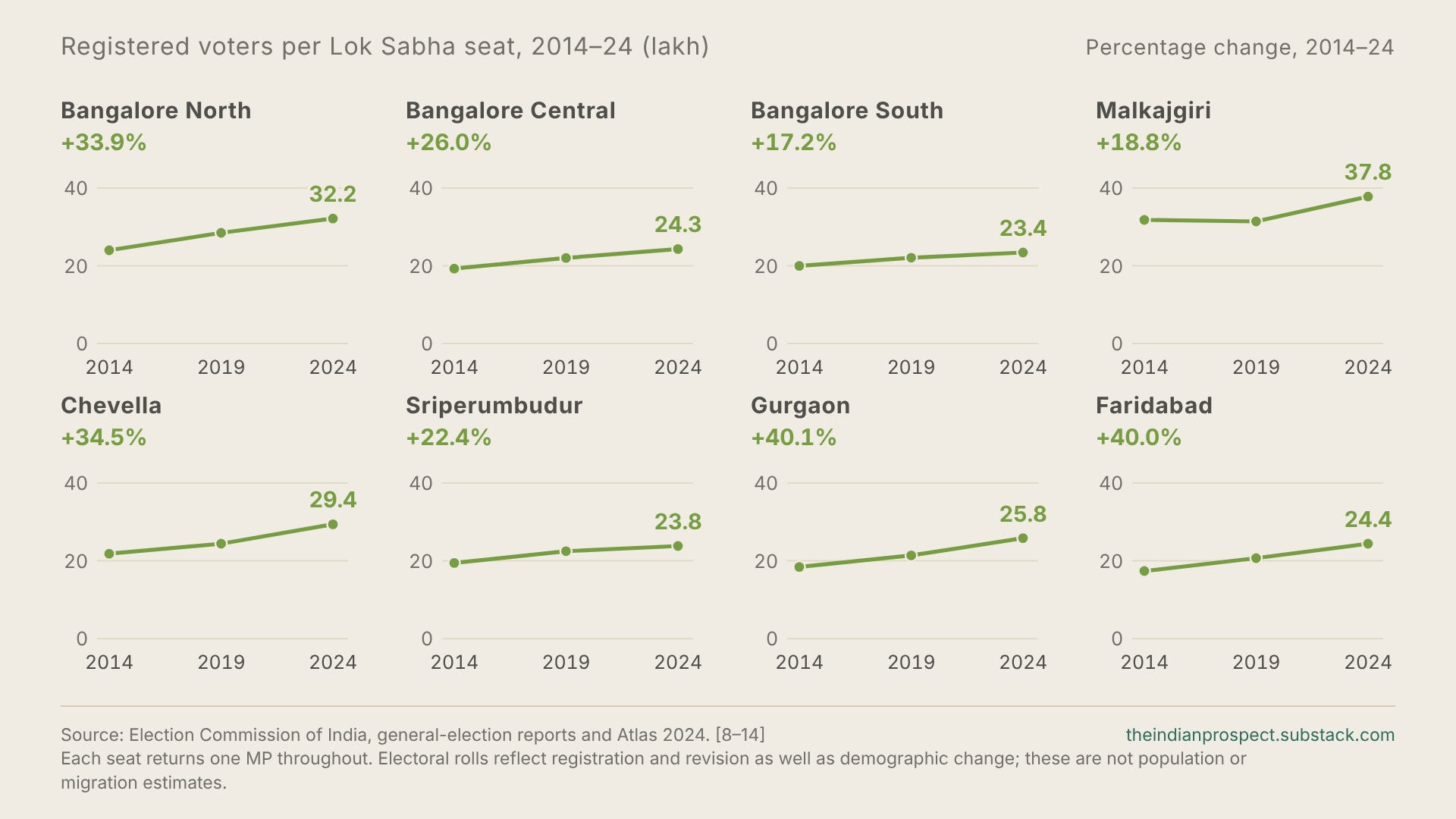
The rapid growth of urban areas has compounded this mismatch in representation. Bangalore North’s electorate rose from 24.01 lakh in 2014 to 28.49 lakh in 2019 and 32.15 lakh in 2024: an increase of roughly 34% in ten years, with one MP throughout.8
Bengaluru belongs to a wider metropolitan pattern. Malkajgiri had 37.80 lakh voters in 2024,9 93% above Telangana’s parliamentary average; neighbouring Chevella had 29.39 lakh, 50% above it. Sriperumbudur, covering part of Chennai’s expanding metropolitan economy,10 had 23.83 lakh, 49% above Tamil Nadu’s average. Gurgaon had 25.85 lakh, 28% above Haryana’s.11 The states might differ but the pressure of metropolitan growth12 is visible across all these constituencies and many others.
For the professional moving towards a more productive job, the consequence is the same; to join an electorate in which far more people must share one parliamentary representative.
A map drawn for 1971
The sheer scale of India’s urban transformation is already visible in its previous censuses. Its urban population rose from 109.1 million in 1971 to 286.1 million in 2001 and 377.1 million in 2011 while the urban share of population increased from 19.9% to 31.1% over those four decades.15 The transformation has continued since then. The official population projections, reproduced in the government’s 2024 social welfare statistics, put the urban population as of March 2026 at 513.5 million, or 36.0% of India’s population.16 Many estimates put the figure even higher of course though only the coming census19 can settle it conclusively.
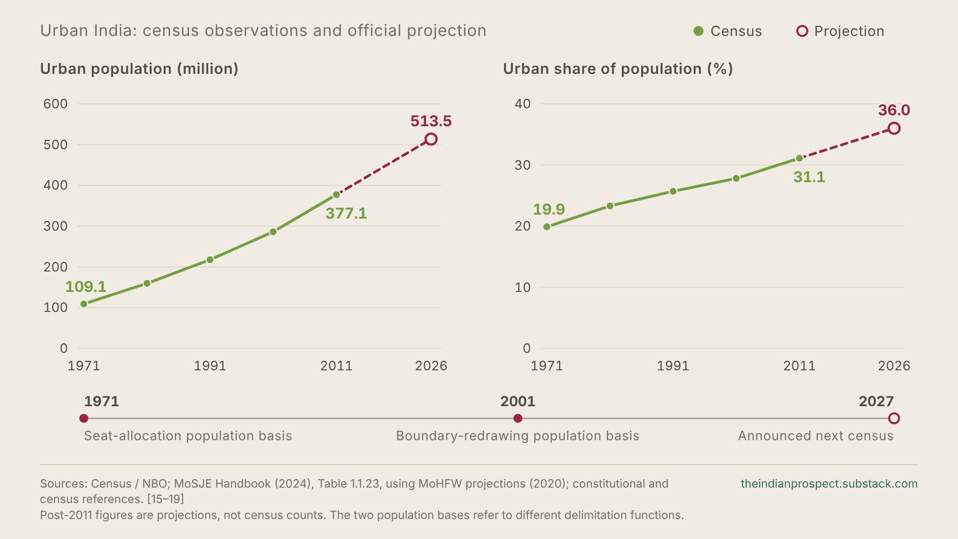
Even as the country has grown, representation of its citizens has adjusted unevenly. The 42nd Amendment in 1976 froze the various states’ Lok Sabha allocations and Assembly seat totals with the 1971 census as its basis. The stated rationale then was to avoid penalising states pursuing population stabilisation programmes, particularly the ones supported by the centre. The 84th Amendment in 2001 extended the freeze with the constitutional trigger for the next delimitation being the publication of the relevant figures from the first census after 2026.17
While the freeze was meant to reward states that slowed their population growth, some of its most significant victims are the cities that absorbed India’s migrants.
Boundary revision of constituencies however followed a different clock. The 87th Amendment in 2003 permitted the use of 2001 population figures for the general delimitation exercise whose orders were finalised in 2008. As a result, the basis for allocating seats between states is from the 1971 census, while the last general redrawing of constituency boundaries within states used the 2001 census.18
The bill for an under-represented city
Back to the question of cities, the 1971 and 2001 population bases would matter less if cities could pay for their own growth. However, they cannot. Most of the money that builds a city’s water pipelines, drains, roads and other infrastructure is allocated by the governments above it.
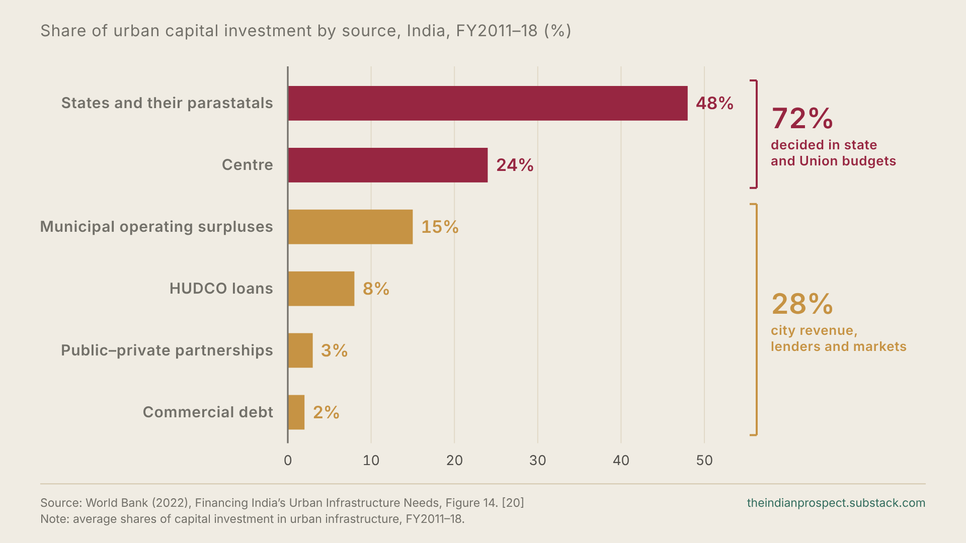
The World Bank’s study of urban capital investment between 2011 and 2018 found that states and their agencies supplied about 48% of investment and the Centre about 24%. On the other hand, municipal surpluses supplied 15% with HUDCO loans, commercial debt and public–private partnerships made up the rest of the investment.20 Nearly three-quarters of urban investment is therefore allocated through state and Union budgets, where it competes with every other claim made on those governments. As a result, a city’s share at least partly depends on the weight its residents carry in the legislatures that pass them.
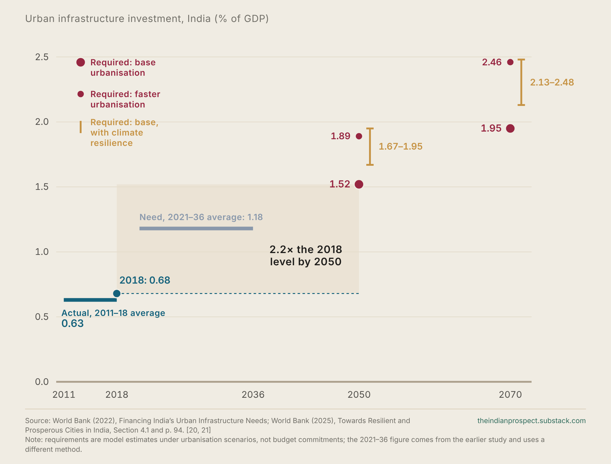
More acutely, the amounts allocated have been far below what urban growth requires. The World Bank’s 2025 report, prepared with the Ministry of Housing and Urban Affairs, puts India’s spending on urban infrastructure at about 0.68% of GDP in 2018. As per the report, that share must more than double, to 1.52% of GDP by 2050 to serve the urban population it projects and that is before any spending on climate resilience. The likely prospect of faster urbanisation or critical investment in resilience to floods and heat would push the requirement higher still.21
The same report estimates that more than half the urban infrastructure India will need by 2050 has not yet been built, as the urban population rises from about 480 million in 2020 towards 951 million then.21 A reality of infrastructure is that infrastructure laid ahead of settlement is relatively cheap; drains can follow the slope, space for utilities can be arranged ahead of construction and water mains can go in before the buildings above them. Retrofitting after construction has already taken place is far costlier and often physically impossible, so each year of underinvestment at present ends up hardening a layout that later spending can only partly correct and only at a much greater cost.
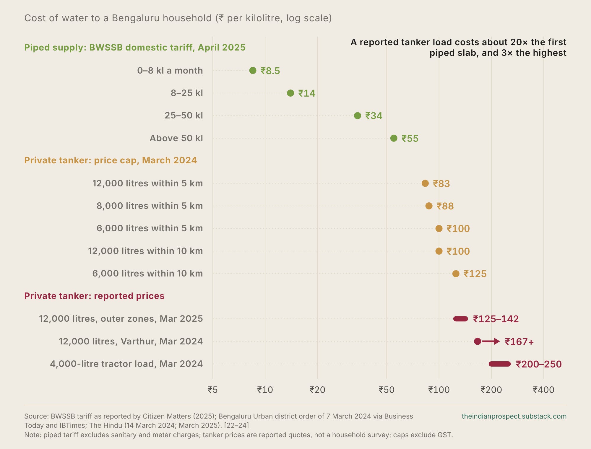
Back to the present, when public investment falls short, households pay twice, once through taxes for public services, and again for private substitutes. Bengaluru ended up paying for the second bill during the 2024 drought.22 During the drought, the residents of Varthur and Marathahalli, on the eastern technology corridor, reported paying more than ₹2,000 for a 12,000 litre private tanker load.23 By March 2025, tanker loads in the outer zones of Bengaluru were again selling at ₹1,500 to ₹1,700, in areas where piped Cauvery water supply remained sparse.24
At ₹2,000 a load, water costs a household about ₹167 a kilolitre. That price is the private cost of a public network that has not kept pace with the parts of the city that grew fastest and in many cases, contributed very substantially to the state’s exchequer. The same arithmetic applies to backup power, sewage tankers, flood repairs and the myriad other quick fixes that Indian cities are forced to rely upon due to the failure of sufficient infrastructure. The World Bank estimates that stormwater flooding already costs Indian cities about $4 billion a year, and expects that to reach $5 billion by 2030.21 These costs fall on households and firms rather than on any public budget, which is why they rarely enter arguments about what cities receive.
Indian cities already produce an estimated 63% of the country’s GDP, and the World Bank expects them to generate 70% of the country’s new jobs by 2030.21 When their water, transport, drainage and other basic infrastructure falls behind, the cost appears as costlier housing, lost working time and jobs that are harder to reach, and eventually as slower national growth. In a situation where most urban investment gets decided by state and Union governments, the question is why those governments direct so little of it to the places producing most of the growth and contributing disproportionately to their exchequer.
How weak political weight becomes an everyday cost
The connection between representation (or the lack of it) and the condition of Indian cities runs through political incentives. Political parties devote attention, allocate leadership positions and make promises around the constituencies that they need to win. When a rapidly growing metropolitan electorate remains crowded into an unchanging number of seats, its rising demand for housing, transport and other services fails to acquire any corresponding increase in parliamentary weight.
The United States offers a rather clean test of the same mechanism playing out in another political system. Until the 1960s many American state legislatures were badly malapportioned, with some counties holding far more seats per person than others. Court rulings beginning with Baker v. Carr in 1962 forced states to equalise the populations of their legislative districts within a few years. Stephen Ansolabehere, Alan Gerber and James Snyder traced what happened to state money post equalisation. Prior to redistricting, counties with more legislative seats per person received more state transfers per person. Afterwards, counties that lost seats received a smaller share of state funds. The authors estimated that equalisation shifted about $7 billion a year from formerly over-represented counties to formerly under-represented counties. The money simply followed the voters legislators now had to answer to.25
Money follows seats, and India’s cities are short of both.
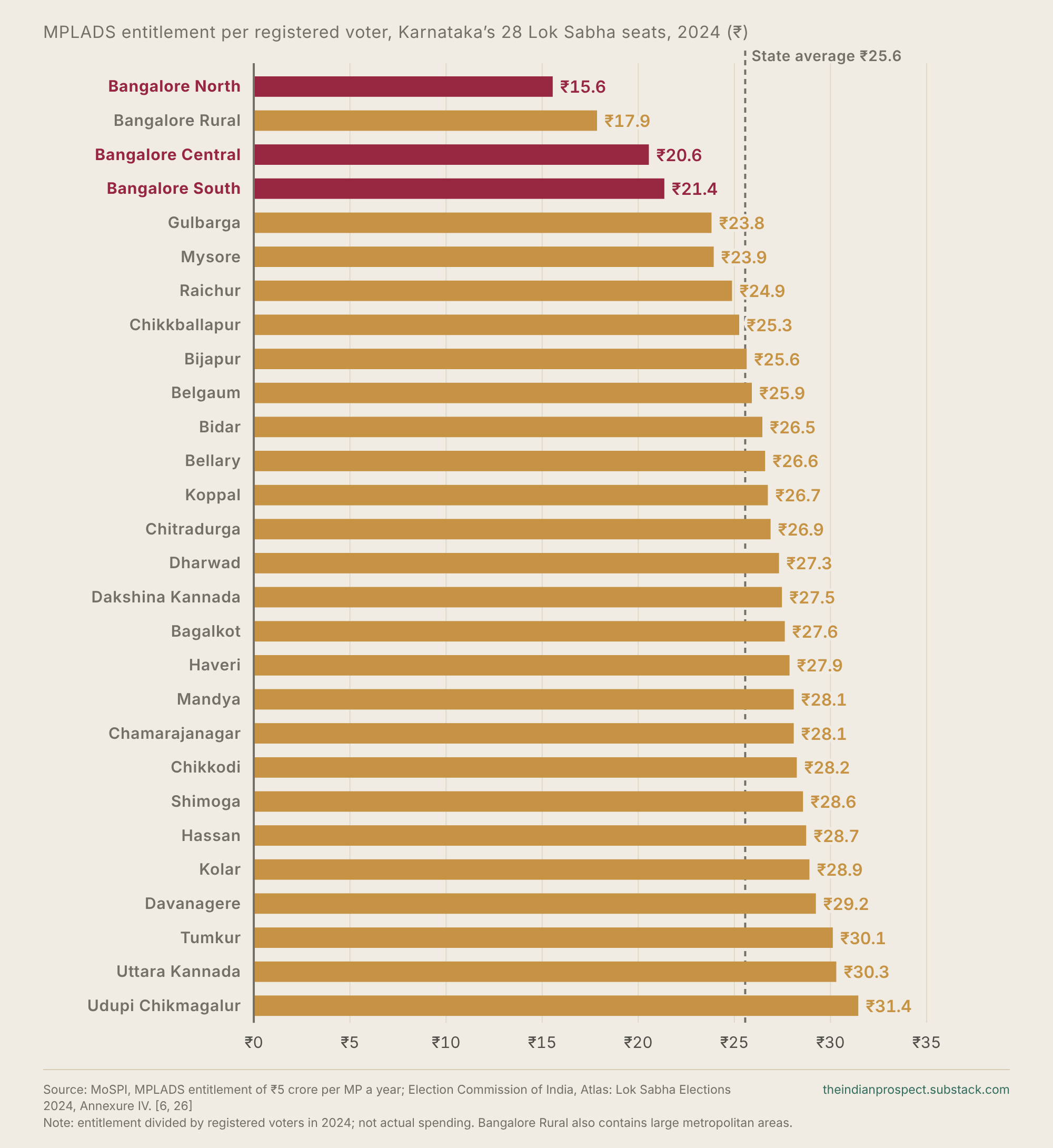
India has a small and direct version of the same arithmetic. Under the MPLADS scheme every MP may recommend ₹5 crore of local works a year, whatever the size of the constituency.26 Spread across Bangalore North’s 32.15 lakh registered voters, that comes to about ₹16 per voter; while for Haveri’s 17.94 lakh voters, that instead comes up to about ₹28 per voter.6 MPLADS as a scheme is not too relevant to explain urban underinvestment by itself, but it shows the principle at work; wherever resources attach to a seat, an oversized constituency divides the same entitlement among more people.
This lack of adequate representation matters most for decisions that households cannot make for themselves. For example, a salaried professional in a city can change apartments or employers, but he cannot approve for more housing near an office district, or coordinate a metro line, or compel agencies to complete connecting roads. For any such coordination, the constituent requires a responsive representative. Failures of coordination at the governmental level instead arrive in household budgets as higher housing costs and in working lives as lost time.27
While more parliamentary representation cannot deliver these services by itself, it can increase the number of seats for which their delivery matters thereby strengthening the significance of urban demands inside the political system. Whether that pressure produces a better city then depends on the institutions through which it acts.
Responsibility without authority
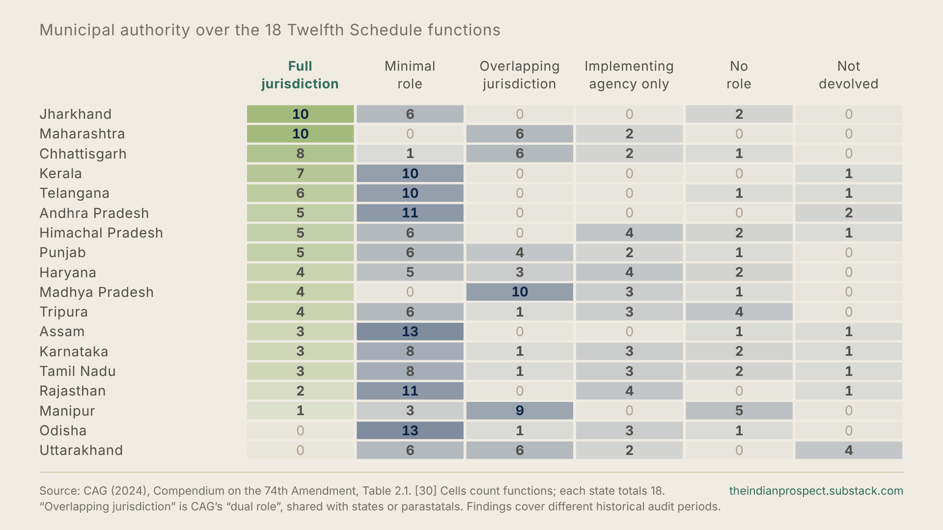
It is these institutions that are the next problem. On paper, the 74th Amendment of 1992 gave urban local government a long list of responsibilities. It had listed 18 functions in the Twelfth Schedule, including planning, roads and water supply. In practice however, Article 243W only allows state legislatures to transfer these powers over, it does not require them to do so and many states choose not to.28
Take Karnataka, A CAG audit found that while the state had formally devolved the seventeen functions to its urban local bodies, they were solely responsible for just three.29 Key functions such as land use, transport, water and street management are instead spread across various state departments. The CAG’s 2024 compilation found much the same picture in state after state.30 So when a Bengaluru road floods, the council, the water board and the development authority can each say, with some justification, that it is not entirely their job.
Further, even within its own domain, the elected council is often not in charge. In most cities executive power instead rests with a commissioner appointed through the state’s systems rather than with the mayor, a situation that NITI Aayog identifies as a central weakness of Indian city government.31 Bengaluru’s new arrangement goes a step further, with the Chief Minister heading the Greater Bengaluru Authority.32
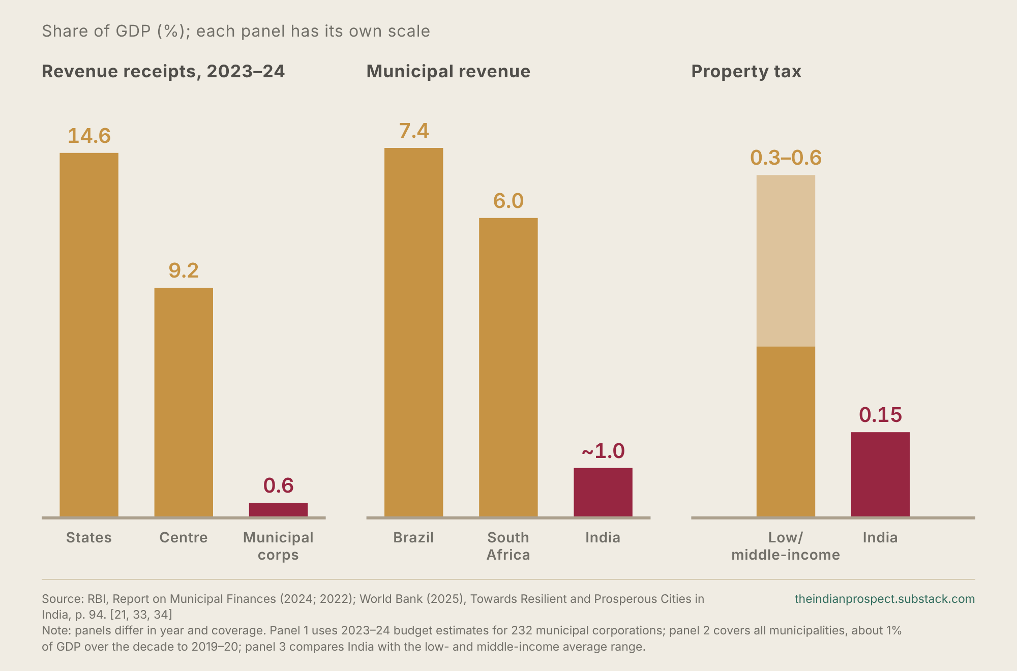
Then there is the money. States decide what cities can tax, how much they can borrow and which projects get approved.20 The result is city governments with remarkably little revenue of their own. The RBI puts the revenue receipts of the country’s 232 municipal corporations at about 0.6% of GDP in 2023–24.33 Even counting every smaller municipality, municipal revenue has hovered around 1% of GDP for a decade, compared with 7.4% in Brazil and 6% in South Africa.34 What comes from the state often arrives already spent. Karnataka’s State Finance Commission set aside ₹34,052 crore for the state’s cities in 2026–27,35 yet only ₹4,972 crore of it reaches elected urban governments. Nearly 90% of that is tied up in salaries, electricity bills and loan repayments before a council gets to decide anything.36
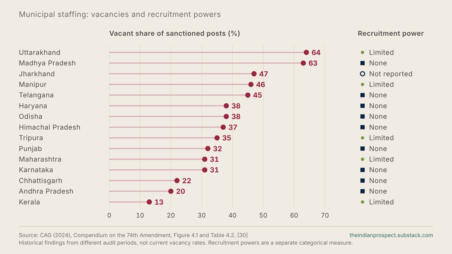
Councils also have little say over who works for them. The CAG found that municipalities had no power to recruit their own staff in ten states and only limited powers in six more, and that on average 37% of sanctioned posts were vacant.30 A city expected to deliver a far larger investment programme would need many more engineers, planners and accountants, and in much of India it cannot hire them itself.
Like a cherry on top, sometimes there is no elected council at all. At the time of the CAG’s audits, 1,600 of 2,625 urban local bodies across seventeen states were without one. Bengaluru has gone without an elected council since 2020, a gap that has cost it ₹964 crore in Finance Commission grants that required one.35
None of this can be fixed by the cities themselves. Each of these barriers comes from the Constitution or from state law, which means only legislators can remove them, and whether they choose to do so depends on how much the cities count for in the Assemblies and in Parliament.
What parliamentary delimitation can change
In April 2026 the government brought three bills to a special sitting of Parliament. The Constitution (131st Amendment) Bill would have raised the Lok Sabha’s ceiling to 850 seats and removed the freeze that has fixed each state’s share of seats since 1976. Additionally, it would’ve allowed delimitation on the basis of the latest published census, in this case 2011, so that women’s reservation could take effect before 2029. The Bill’s statement itself cited rapid urbanisation, migration and shift of population between and within states among the reasons for change.37 On 17 April it received 298 votes38 against 230, short of the 352 needed for a two-thirds majority, and the government withdrew the Delimitation Bill.41 Opposition parties objected to linking women’s reservation to delimitation, and southern parties were particularly stubbornly opposed to it as reallocating seats by population would reduce their states’ share and leave them much weaker politically.
The government has since been reported to be seeking support to try again,39 possibly in a special session, though no timetable has been confirmed as of yet.40 For cities, the decisive question related to the bill is whether growing urban regions gain a larger share of representation.
Two decisions are often run together when it comes to delimitation. Interstate allocation determines how many MPs each state receives; redistribution within a state determines where those seats lie.42 For cities the second decision matters most, and it can be taken on its own. Redrawing constituencies within each state on updated population would correct the imbalances documented above without running into the far more fractious debate of how many seats each state should hold. India has done this before, the delimitation exercise completed in 2008 redrew boundaries based on 2001 census figures while leaving every state’s seat share at its 1971 level.18 Tying the urban case to the interstate dispute would make it hostage to the hardest bargain in Indian federalism.
Coming back to Karnataka, Bangalore North, Central and South constituencies together contained 14.6% of Karnataka’s registered voters in 20246 but held only 10.7% of its parliamentary seats. Matching those shares would give this electorate the equivalent of just over four seats instead of three.12
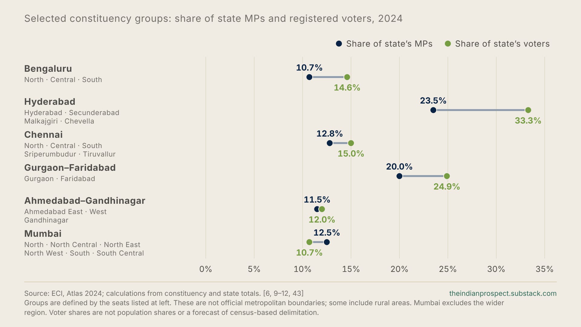
Shamika Ravi and Mudit Kapoor’s 2026 working paper for the Economic Advisory Council to the Prime Minister, which analyses constituency size across parliamentary elections, illustrates the same. In its simulation of an 824-seat Parliament, the Hyderabad and Secunderabad footprints rose from two of Telangana’s seventeen seats to six of twenty-six and from 11.8 to 23.1%, such that a larger house also gave the city a materially larger share of the say in it.44
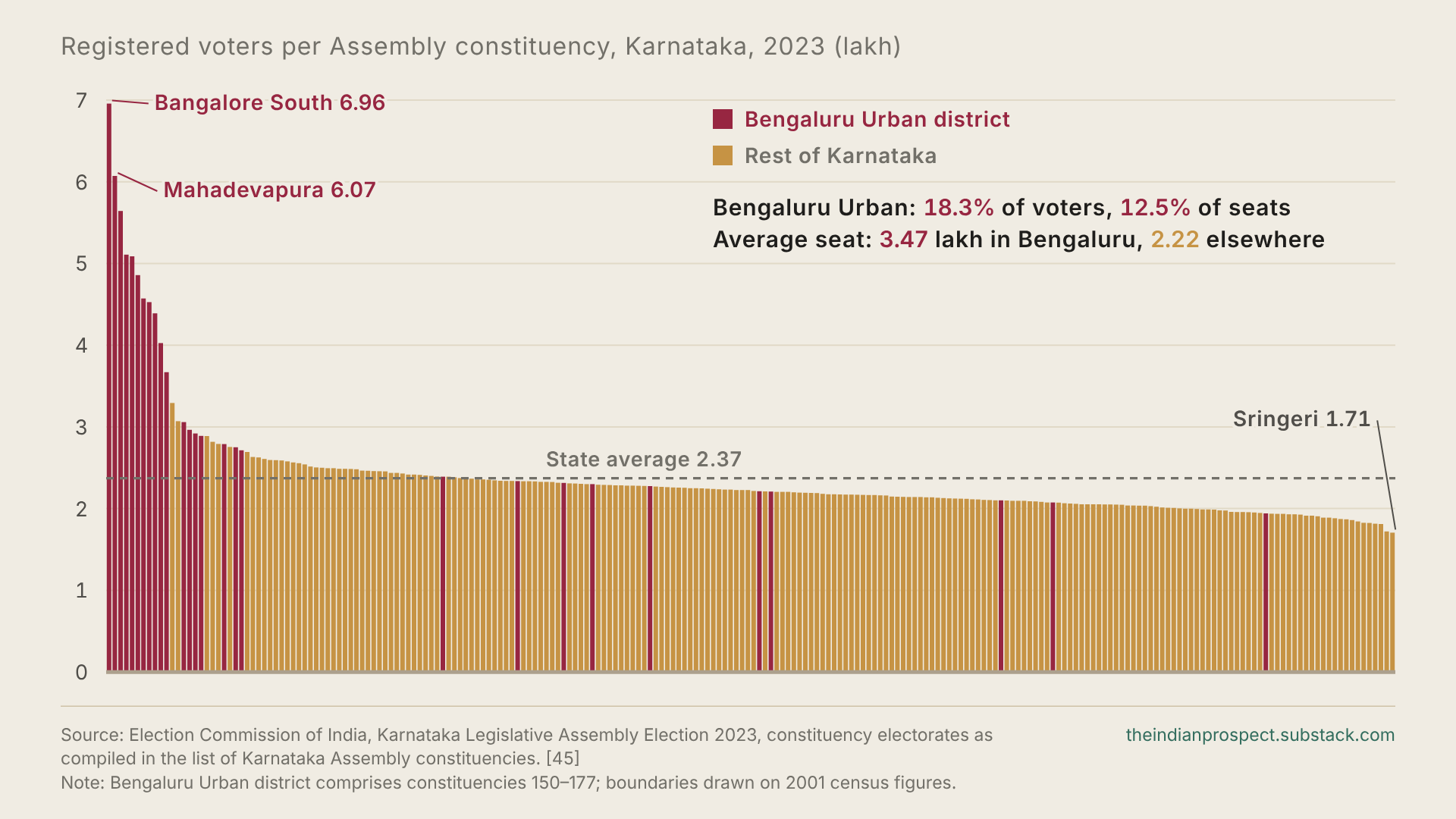
The same logic applies to an even greater extent to the State Assemblies, which hold most of the powers described in the previous section. Karnataka’s Assembly constituencies were last drawn based on 2001 census figures. By 2023 the largest constituency, Bangalore South, had nearly 7 lakh voters, about four times the 1.71 lakh in the smallest, Sringeri. Similarly, Mahadevapura, covering much of Bengaluru’s eastern technology corridor, had about 6.1 lakh. Overall, Bengaluru Urban district held 18.3% of the state’s voters but just 12.5% of its Assembly seats.45 As a result, its MLAs answer to far more people than most colleagues in the Assembly that writes Bengaluru’s municipal law and passes its budget.
The case against, and why it does not hold
The urban case for delimitation faces three significant objections.
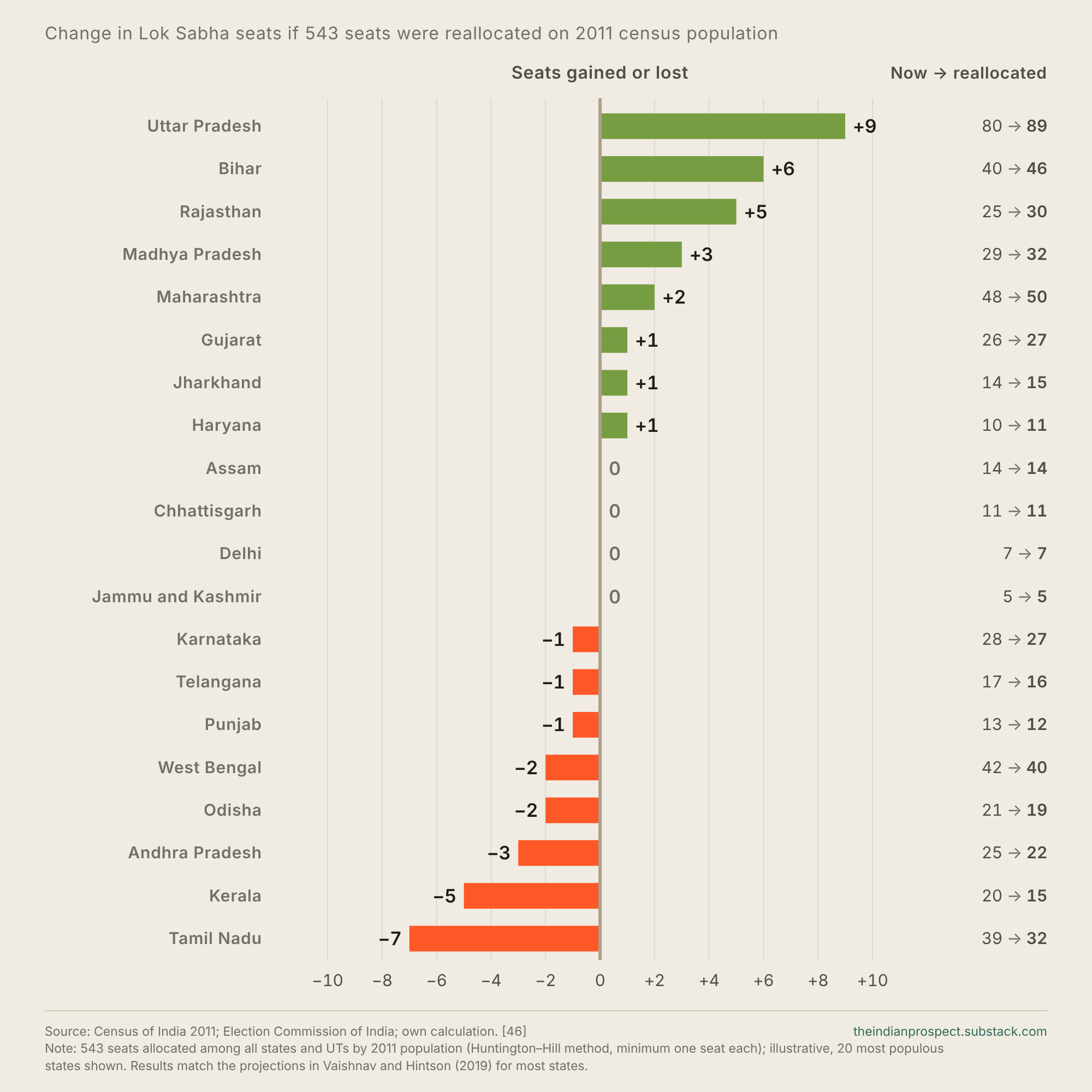
The first is the fear in the southern states that population-based reallocation will reward states that brought down fertility more slowly while penalising those that were more diligent in meeting earlier government recommendations. Reallocating the existing 543 seats on the 2011 census population, the basis the April bill would have used, would take seven seats from Tamil Nadu and five from Kerala, while Uttar Pradesh would gain nine and Bihar six. Projections based on more recent population figures show even larger shifts.46 While this concern is a major factor in several states and helps explain one of the reasons for the April defeat. It is also separable from the case for redistributing seats to urban areas. Redrawing seats within states only changes where each state’s seats lie, not how many seats a state has. States like Karnataka, Tamil Nadu and Telangana, which contain several of the most under-represented metropolitan seats in the country, would lose nothing by such a change.
The second objection is that rural constituencies are already geographically large and at times hard to serve, so shifting seats towards cities would weaken rural representation. That argument only has force for certain sparsely populated areas, and the delimitation law already lets commissions consider geography, communications and public convenience when drawing boundaries.42 While it is something to take into consideration, it does not justify the present state of Bangalore North carrying almost 80% more registered voters than Haveri, a gap produced by growth rather than terrain.
The third objection is that urban electoral rolls are often unreliable due to the transient nature of migration, so the figures used here may overstate urban growth. However, the evidence points in the opposite direction in this regard. Many workers who move to cities remain registered in their home constituencies, often going back home to vote. Further, the Election Commission has identified the inability of internal migrants to vote as a prominent reason for low turnout.47 Delimitation uses census population, not electoral rolls, so a census-based redraw would count these residents where they actually live. The electoral rolls based comparisons used throughout this article are therefore more likely to understate the urban imbalance than to overstate it.
A map for the India that exists
All together, more urban seats would increase the number of political and electoral contests in which metropolitan conditions matter directly. National parties and other parties competing in urban areas would have stronger reasons to develop credible positions on housing, transport, urban investment and municipal finance, and urban representatives could press for them inside their parties. The growing city would therefore become more costly to neglect or use as a cash cow.
That is a shift that would be good for Indian politics. A professional renting near his workplace shares economic interests with many other people whose caste, language or place of origin differs from his own, the construction worker on the next site, the delivery rider, the domestic worker, all might find far more in common with each other and with a salaried professional in a city than they might if they stayed back in their villages. The 2011 census counted 65.5 million Indians in informal urban neighbourhoods, with at least as much at stake in water, drainage and secure housing as any salaried household.21 All of them need infrastructure that’s reliable, housing they can afford, transport that works and rules they can rely on.
As these voters account for more constituencies, that incentivises the parties to compete for them on an agenda that surpasses inherited identities. Caste and other identities will of course remain politically important, but they need not crowd out interests formed around work, income, property and the cost of living. This will eventually play a key role in the ‘de-dehatification’ of Indian polity and help build a more progressive political culture.
Census-based delimitation is among the most basic places to begin. It applies a principle that the constitutional framework already provides; seats and boundaries should be readjusted as the population changes.17 The first task is to establish where Indians now live. The next is to give growing urban populations their proper share of seats in Parliament and the Assemblies, through a redraw within states that need not wait for the harder interstate settlement.
Delimitation would not by any means complete the reform of India’s cities. Nonetheless, it would give impetus to that reform, by making urban voters a constituency strong enough to carry it. Giving urban residents a fair share of political power is one of the simplest principles of democracy, and one of the most important investments India can make in its development.
The distinction between reallocating seats within a state and between states is useful. Would a within-state redraw alone change urban infrastructure budgets much, or would cities still need stronger municipal taxing and spending powers first?